The Importance of Tactile Maps for Blind People
Growing up as the only blind child in a school full of sighted children, I had fewer opportunities to explore tactile maps by touch than they had to look at visual maps. I learned that some tactile maps were created by my parents, and others were found in the Braille textbooks that my teacher borrowed from a library for the Blind. Because my opportunities were limited, I vividly remember the times when I learned about geography through touch.
Now, maps are a frequent topic of conversation in my work as an accessibility consultant for museums. Think of museum maps as falling into one of two categories—wayfinding and exhibit content.
Wayfinding maps help visitors navigate the museum building performing tasks like finding the elevators, restrooms, and exhibits. Visual maps used for wayfinding are routinely handed out in brochures or posted prominently on large signs. Occasionally, I find tactile maps on display in the lobby near the entrance of the museum. Sometimes, museums include tactile maps in their Braille guides, but in most cases the guide only contains the text of the printed exhibit labels.
Exhibit designers often use maps to communicate information about the content of an exhibit. For example, a map might show the locations of historic forts and towns when the exhibit is about a historic period. Maps might show where particular plant or animal species are located, or the extent of geological features like mountain ranges and rivers. Information can be shown visually in print or digital formats. I have had conversations with museum staff about communicating the same information through touch on tactile maps that are created with raised lines or modeled in 3 dimensions. To be effective, both visual and tactile maps must convey spatial knowledge.
Types of Spatial Knowledge
Scholars have described three types of spatial knowledge.
• Landmark Knowledge: name, type, shape, orientation, and size of a particular feature or location on the map.
• Route Knowledge: distance between landmarks and the direction of travel.
• Survey Knowledge: general layout of all landmarks on the map, including distance, direction, shape, size, and orientation.
These three types of spatial knowledge clarify which map designs effectively communicate information and which do not. Both tactile and visual maps can help people acquire spatial knowledge.
Learning Geography Through Touch
Reflecting on discussions with museum staff, I can recall childhood experiences of how I learned about geography through touch. Tactile maps have helped me understand geography, from the world at large to my own childhood neighborhood.
When I was a young child, my parents used glue to trace the outlines of the continents on a print world map. When the glue dried, I could feel the raised lines. To this day, my perception of a world map is of many different shapes on top in the northern hemisphere, and lots of blank space on the bottom representing the oceans in the southern hemisphere. I acquired landmark knowledge, recognizing the shapes of the continents, and survey knowledge of how they are laid out on the map.
My father mounted that map on my bedroom wall where it stayed until the glue dried up and fell off some years later. There will always be a need to create low-tech tactile maps for an individual or a small group of people. Maps with raised lines made with glue or puff paint might be sufficient to convey information in an afternoon program, but they won’t survive the touch of many hands when an exhibit is open for weeks, months, or permanently.
I learned the shapes of most of the U.S. states by assembling a wooden puzzle. My parents must have purchased it from a local store because it only had print labels. Some stores sell and ship tactile maps and puzzles with both Braille and print labels. Now, a parent or teacher of a blind child can find and order Braille products online, but when I grew up, orders were placed by phone or postal mail. That process was time consuming and sometimes my family purchased products from local stores that just happened to have tactile features.
The U.S. puzzle consisted of a wooden frame that showed the borders of the 48 continental United States, excluding Alaska and Hawaii. When it was assembled, the wooden puzzle pieces fit inside that frame. I learned about the general size and shape of the country by assembling that puzzle.
Borders formed by water are irregular in shape when compared to land borders. California is shaped like a banana with a squared off top; its curved edges fit naturally along the far lefthand, Southwest, corner of the puzzle along the coast of the Pacific Ocean. Texas resembles an irregularly shaped star, and it is known as the Lone Star State. The narrow point of South Texas fits along the coastline of the Gulf of Mexico in the lower center of the puzzle frame. Florida is long and skinny fitting into a point at the far righthand, southeast corner of the puzzle frame.
Land borders are more regular in shape than the coastal borders of the United States. In later years, I learned that survey crews were sent to establish the borders of many western U.S. states. As a result, many of them are generally square or rectangular in shape.
When I was learning how to complete that puzzle, my mother taught me to recognize the shapes of the states by touch. There are slight differences in size and shape that can be observed both by touch and by sight. She handed me each state and showed me where it fit in the puzzle.
She taught me the states from west to east because I grew up in the southwestern state of Arizona—fitting against California and Nevada. Moving north, Utah is placed above Arizona and Idaho fills the space between Utah and the Canadian border. Moving east, the next column from south to north is New Mexico, fitting between Arizona and Texas, then Colorado, Wyoming, and Montana.
Remember that one function of maps is to communicate survey Knowledge, the shape of features, and their location relative to other features on the map. Now I turn to consideration of incomplete survey knowledge. The larger states on my childhood puzzle were represented by separate pieces of the puzzle, but the smaller states were not. One rectangular piece represented most of the New England states of Connecticut Massachusetts, New Hampshire and Vermont with print labels.
This rectangular New England piece fits vertically near the top right, northeastern, corner of the puzzle between New York and Maine. I did not know exactly where New Hampshire was located until I was an adult taking a bus along the Atlantic coast from Boston Massachusetts to Portland Maine. We passed through part of New Hampshire during our trip.
When I was a teenager, my parents made a braille street map of our neighborhood. I do not remember the production methods, but it was on a hard surface with a plastic overlay of raised lines and street names written in Braille letters. A square marked the location of my school. My parents made that map to teach me route knowledge, the directions between places. When I was learning the route between our home and my school, I traced my finger along our street to the next block, turned right, and continued tracing the several blocks to reach my school. I learned that route before I needed to walk to school each morning.
My early exposure to tactile maps, though limited, helped me develop spatial thinking. If I wish, I can imagine myself moving along the lines of a street map when I am walking or riding in a vehicle. If I am flying between cities in the 48 continental United States, I can think of my departure and arrival locations as dots on the U.S. map.
The neighborhood map that my parents made did not have a key, but it introduced me to the concept of showing information with different shapes and lines. The lines that represented the streets, and the square that marked the location of my school are examples of symbol sets.
When I was given a Braille textbook with tactile maps, I learned how to identify geographic features using a key. I learned to use tactile symbol sets to identify map features (landmarks) and understand their layout (survey knowledge).
A symbol that is essential on wayfinding maps is the star that indicates “you are here”. It marks the location of people examining large maps on signs in buildings like airports, train stations, or large museums. The star helps people understand where they are located on the map, allowing them to orient themselves to the building. Then they can plan a route to their departure gate in a transit station, or to a specific gallery in a museum.
Alexander Kent (2019) observed that people sometimes alter these large street maps by their touch. Maps get worn out through interaction with their users; from misfolded paper maps to “obliterated ‘You are here’ symbols on street maps, rubbed off by countless fingers over time and often indicating the user’s location more poignantly than the original symbol as a result”. Kent also reports that metal 3D models of cities are polished by many hands touching them.
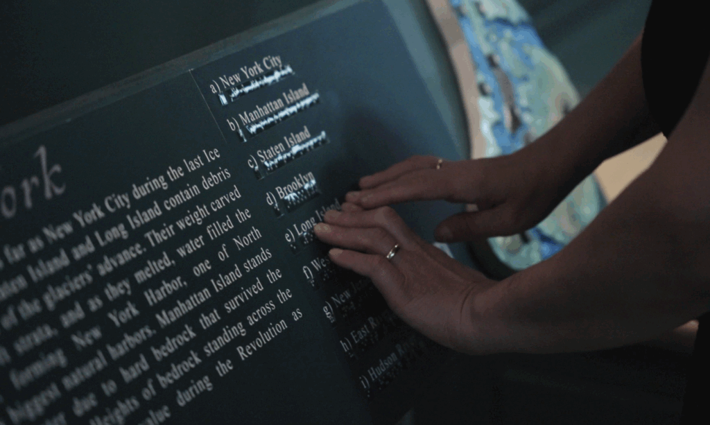
Maps are essential for learning about many subjects ranging from geography and history to biology and geology. In my work with museums, I am often asked about tactile maps. For example, staff at a historic fort wanted a map that showed the coast, and the islands. Water is usually lowest in elevation with islands shown as raised areas. Braille letters identify locations on tactile maps just as print letters perform the same function on visual maps. The map in the featured image for this story shows New York City. It was produced by Proximity Studio and it was displayed at Fort Ticonderoga, New York during 2024.
Through early exposure to tactile maps, I developed robust spatial thinking skills. My experiences highlight the value of multisensory learning tools—especially tactile maps—for blind people. These maps have taught me fundamental concepts of geography and orientation, and they have also empowered me to navigate and make sense of my environment. I know the practical considerations involved in designing tactile maps for museums where symbols and labeling must be clearly conveyed for effective use. Tactile maps can make information accessible for blind people, and anyone who learns best through touch.
I appreciate the importance of maps—both tactile and visual—as essential tools for learning across many disciplines, from geography to history and beyond. Museum exhibits can provide multisensory experiences by including tactile and visual maps. In this way, all visitors can learn about the content of their exhibits.
References
Kent, A.J.
(2019) Maps, Materiality and Tactile Aesthetics The Cartographic Journal 56 (1) pp.1–3
Kim, K., & Bock, O.
(2021). Acquisition of landmark, route, and survey knowledge in a wayfinding task: in stages or in parallel?. Psychological Research, 85(5), 2098-2106.
Tverksy, B.
(2018). Levels and structure of spatial knowledge. In Cognitive mapping (pp. 24-43). Routledge.